Cycling around Audlem’s lovely lanes
Cycle routes around Audlem – from ADAPT
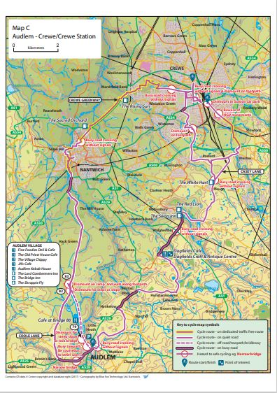
ADAPT (Audlem and District Acting Positively for Transition) has produced a series of maps showing local cycle routes on lands, towpaths and bridle ways. The maps are free to download.
How the maps were made
Back in 2021, CPRE Trustee, Rev. John Whitehead, wrote about how the cycle route scheme started.
Albert Einstein once wrote: “I thought of [the theory of relativity] while riding my bicycle”. Three years ago, I went with a group of Audlem fellow citizens to Nantwich Civic Hall to attend an innovative Cheshire East Council Auction of funds for local voluntary groups. This was part of its Participatory Budget Programme aimed at promoting public health. Each group, and there were a good number, had to bid for funding by making a presentation on the stage – ours was creative and amusing – and then at the end everyone voted the points for each project. Some groups achieved nothing, but ADAPT (Audlem and District Acting Positively for Transition) came away with £3,000 funding for a Cycle Route Mapping Scheme.
Like a great many of my generation born in 1940’s and 50’s, I used to cycle to school, meetings and recreation with friends, thinking nothing of 20 mile rides on normal roads. Nowadays the ubiquity of the car, vans, etc. has made cycling a safety problem on many roads, which is why a cycleway map showing bike routes on lanes, towpaths and bridle ways, avoiding busy roads where possible, meets a growing need. With financial support from Cheshire East Council and, more recently, local businesses and organisations, ADAPT has now produced a free map of 30 cycle routes in this part of South Cheshire and beyond. Helpfully the map indicates places of interest, cafes, etc. en route.
This is just one way in which ADAPT is working on the Transition which Climate Change consequences like pollution, flooding and effects on public health are making increasingly urgent. Just as importantly, cycling in the countryside refreshes the spirits in so many ways!
While hard copies of the free map are available in local outlets, the main access to detailed route information has been on the internet via Audlem’s vibrant community website, Audlem Online. The maps can be found at https://adapt.audlem.org/maps.html, and are free to download. To date at least 750 visits have been logged for each route, so local map-guided biking has obviously taken off. The project has involved many hours of hard work and perseverance by the ADAPT Transport Group team and has recently been complemented by another successfully delivered project to install Audlem’s first cycle parking facilities in the village centre. A further spin-off from the project has been an ambition to provide an improved route between Audlem and Nantwich and sections of the canal towpath and around Nantwich lake have already been completed.
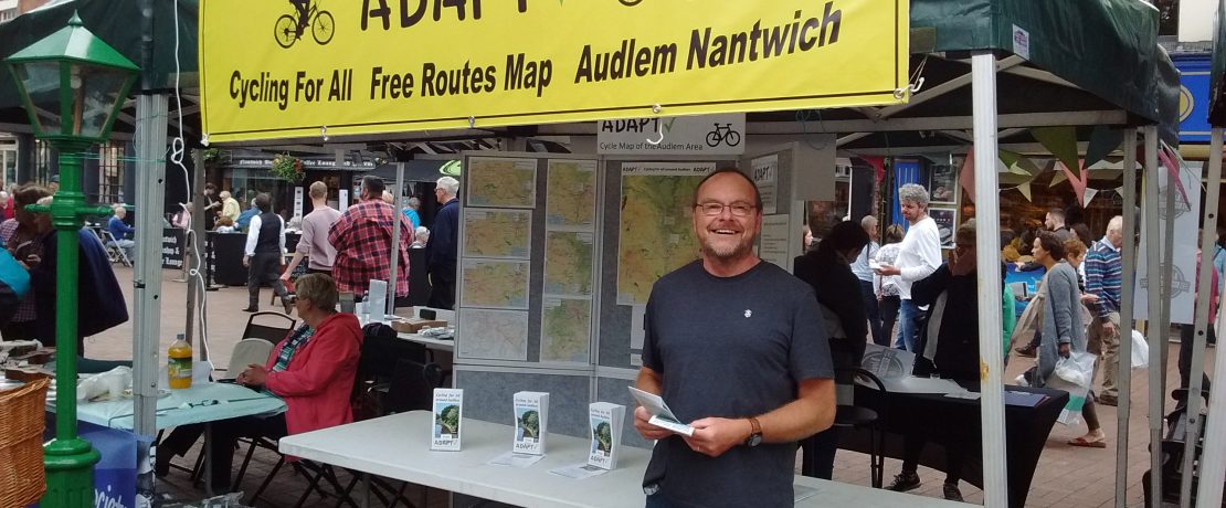
Andy Hannah, pictured above, is a member of the ADAPT team who developed the maps. He told us, “The ADAPT cycle map has been amazingly popular. We have distributed over 10,000 paper maps and are now on our 4th print run. People keep asking for more, and the website statistics show that they are actually using them to download the route packs. The countryside round here is marvellous for cycling, and it’s a joy to make journeys in such peaceful surroundings. But the busy narrow main roads put people off from cycling, so that’s why we wanted to show how to get around avoiding them where possible. Our aim was to encourage new and returning cyclists, and we are increasingly seeing those on our routes, particularly during the covid pandemic.”
In so many ways this village initiative points the way – the Transition – to a healthier, carbon-reducing and personally nurturing future for our countryside in Cheshire.